IMAGES TAKEN NEAR TO
Clarebrand, CASTLE DOUGLAS, DG7 3AH
Introduction
This page details the photographs taken nearby to DG7 3AH by members of the Geograph project.
The Geograph project started in 2005 with the aim of publishing, organising and preserving representative images for every square kilometre of Great Britain, Ireland and the Isle of Man.

There are currently over 7.5m images from over14,400 individuals and you can help contribute to the project by visiting https://www.geograph.org.uk
Image Map
Images are licensed for reuse under creativecommons.org/licenses/by-sa/2.0
Notes
- Clicking on the map will re-center to the selected point.
- The higher the marker number, the further away the image location is from the centre of the postcode.
Image Listing (6 Images Found)
Images are licensed for reuse under creativecommons.org/licenses/by-sa/2.0
Image
Details
Distance
1
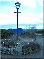
Old Milestone by a garden in Clarebrand, Crossmichael parish
Milestone by a garden in Clarebrand, parish of Crossmichael (Nithsdale District), edge of flower bed with gas lamp.
Inscription reads:-
CD
2
(To Castle Douglas)
Surveyed
Milestone Society National ID: DG_CDDA02
Image: © Milestone Society
Taken: Unknown
0.03 miles
2
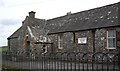
The village hall
Clarebrand village hall.
Image: © Colin Kinnear
Taken: 24 Feb 2008
0.05 miles
3
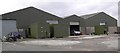
Units
Industrial units in Clarebrand.
Image: © Colin Kinnear
Taken: 24 Feb 2008
0.08 miles
4
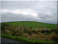
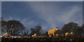
Mote Hill north east of Clarebrand
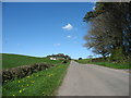
North of Castle Douglas on the Clarebrand to Old Bridge of Urr road.
Image: © Kirsty Smith
Taken: 21 Oct 2005
0.15 miles