IMAGES TAKEN NEAR TO
Laurieston, CASTLE DOUGLAS, DG7 2PL
Introduction
This page details the photographs taken nearby to DG7 2PL by members of the Geograph project.
The Geograph project started in 2005 with the aim of publishing, organising and preserving representative images for every square kilometre of Great Britain, Ireland and the Isle of Man.

There are currently over 7.5m images from over14,400 individuals and you can help contribute to the project by visiting https://www.geograph.org.uk
Image Map (2 Images)


Getting Data...Please wait
Leaflet Map data © OpenStreetMap
Images are licensed for reuse under creativecommons.org/licenses/by-sa/2.0
Notes
- Clicking on the map will re-center to the selected point.
- The higher the marker number, the further away the image location is from the centre of the postcode.
Image Listing (2 Images Found)
Images are licensed for reuse under creativecommons.org/licenses/by-sa/2.0
Image
Details
Distance
1
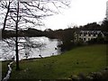
Dornell Estate Cottages
A darkening February day at the upper loch in the Dornell Estate (commercially known as Dornells Shooting & Fishing Estate). The houses to the right are estate cottages.
Image: © Chris Newman
Taken: 26 Feb 2008
0.10 miles
2
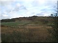
Meikle Dornell
Slopes leading up the hill are the same square. Remarkably unprepossessing hill.
Image: © Kirsty Smith
Taken: 20 Oct 2005
0.24 miles