IMAGES TAKEN NEAR TO
Glenlochar, CASTLE DOUGLAS, DG7 2NZ
Introduction
This page details the photographs taken nearby to DG7 2NZ by members of the Geograph project.
The Geograph project started in 2005 with the aim of publishing, organising and preserving representative images for every square kilometre of Great Britain, Ireland and the Isle of Man.

There are currently over 7.5m images from over14,400 individuals and you can help contribute to the project by visiting https://www.geograph.org.uk
Image Map
Images are licensed for reuse under creativecommons.org/licenses/by-sa/2.0
Notes
- Clicking on the map will re-center to the selected point.
- The higher the marker number, the further away the image location is from the centre of the postcode.
Image Listing (39 Images Found)
Images are licensed for reuse under creativecommons.org/licenses/by-sa/2.0
Image
Details
Distance
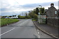
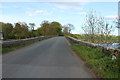
4
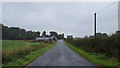
The road to Glenlochar
The minor road approaching Glenlochar from the south.
Image: © Peter Mackenzie
Taken: 1 Sep 2018
0.07 miles
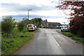
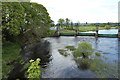
5
Glenlochar Bridge
Over the River Dee.
Image: © Billy McCrorie
Taken: 20 May 2015
0.08 miles
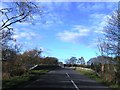
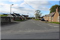
8

Glenlochar village
Viewed on a fine but chilly winter morning.
Image: © Mary and Angus Hogg
Taken: 17 Jan 2022
0.08 miles
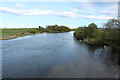
10
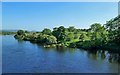
River Dee
Viewed looking downstream from the road bridge in mid-June.
Image: © Mary and Angus Hogg
Taken: 19 Jun 2013
0.09 miles