IMAGES TAKEN NEAR TO
Mossdale, CASTLE DOUGLAS, DG7 2ND
Introduction
This page details the photographs taken nearby to DG7 2ND by members of the Geograph project.
The Geograph project started in 2005 with the aim of publishing, organising and preserving representative images for every square kilometre of Great Britain, Ireland and the Isle of Man.

There are currently over 7.5m images from over14,400 individuals and you can help contribute to the project by visiting https://www.geograph.org.uk
Image Map
Images are licensed for reuse under creativecommons.org/licenses/by-sa/2.0
Notes
- Clicking on the map will re-center to the selected point.
- The higher the marker number, the further away the image location is from the centre of the postcode.
Image Listing (3 Images Found)
Images are licensed for reuse under creativecommons.org/licenses/by-sa/2.0
Image
Details
Distance
1
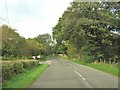
Approaching a road junction on the A762
This is the turning to Crae Bridge and Slogarie Bridge.
Image: © Ann Cook
Taken: 6 Oct 2010
0.13 miles
2
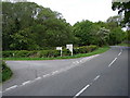
Slogarie Road End
Junction on the A763 south of Mossdale of the lane to Slogarie and other farms and residences.
Image: © Chris Newman
Taken: 19 May 2008
0.14 miles
3
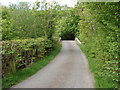
Crae Bridge
Crae Bridge carries the Slogarie road over Crae Lane (stream). The Crae Lane flows from Woodhall Loch into the River Dee.
Image: © Chris Newman
Taken: 19 May 2008
0.24 miles