IMAGES TAKEN NEAR TO
CASTLE DOUGLAS, DG7 2LX
Introduction
This page details the photographs taken nearby to DG7 2LX by members of the Geograph project.
The Geograph project started in 2005 with the aim of publishing, organising and preserving representative images for every square kilometre of Great Britain, Ireland and the Isle of Man.

There are currently over 7.5m images from over14,400 individuals and you can help contribute to the project by visiting https://www.geograph.org.uk
Image Map (Loading...)


Getting Data...Please wait
Leaflet Map data © OpenStreetMap
Images are licensed for reuse under creativecommons.org/licenses/by-sa/2.0
Notes
- Clicking on the map will re-center to the selected point.
- The higher the marker number, the further away the image location is from the centre of the postcode.
Image Listing (6 Images Found)
Images are licensed for reuse under creativecommons.org/licenses/by-sa/2.0
Image
Details
Distance
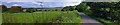
1
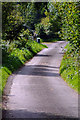
Country Road
Country road, picture taken approx 0.3 miles east of Finniness Farm, looking west.
Image: © Brian Wotherspoon
Taken: 4 Sep 2007
0.01 miles
2
Finniness Plantation (Wood Hill)
Looking West along rural road towards Finniness Plantation in the background.
Image: © Brian Wotherspoon
Taken: 4 Sep 2007
0.02 miles
3
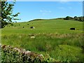
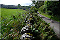
Farmland at Finniness
Sheep and cattle grazing on Galloway's rich land near Loch Ken.
Image: © Mary and Angus Hogg
Taken: 19 Jun 2013
0.06 miles
4
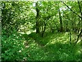
Finniness Plantation
A small patch of mixed woodland near Loch Ken, viewed in mid-June.
Image: © Mary and Angus Hogg
Taken: 19 Jun 2013
0.11 miles
5
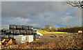
Bales near Finniness
Bales near Finniness Farm.
Image: © Colin Kinnear
Taken: 29 Dec 2022
0.16 miles
6
Loch Ken Panorama
Countryside on the west side of Loch Ken
Approx 0.4 miles west of Livingstone farm
Image: © Brian Wotherspoon
Taken: 4 Sep 2007
0.21 miles