IMAGES TAKEN NEAR TO
Townhead Of Greenlaw, CASTLE DOUGLAS, DG7 2LN
Introduction
This page details the photographs taken nearby to DG7 2LN by members of the Geograph project.
The Geograph project started in 2005 with the aim of publishing, organising and preserving representative images for every square kilometre of Great Britain, Ireland and the Isle of Man.

There are currently over 7.5m images from over14,400 individuals and you can help contribute to the project by visiting https://www.geograph.org.uk
Image Map (13 Images)


Getting Data...Please wait
Leaflet Map data © OpenStreetMap
Images are licensed for reuse under creativecommons.org/licenses/by-sa/2.0
Notes
- Clicking on the map will re-center to the selected point.
- The higher the marker number, the further away the image location is from the centre of the postcode.
Image Listing (13 Images Found)
Images are licensed for reuse under creativecommons.org/licenses/by-sa/2.0
Image
Details
Distance
1
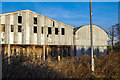
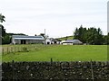
Derelict Barns
Derelict barns at Marchfield.
Image: © Hugh Close
Taken: 28 Dec 2013
0.03 miles
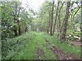
3
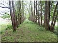
Portpatrick and Wigtown Railway trackbed
North of Castle Douglas.
Image: © Richard Webb
Taken: 14 Jun 2022
0.11 miles
4
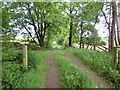
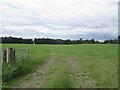
Farm road, Townhead of Greenlaw
Crossing the trackbed of the Portpatrick Railway.
Image: © Richard Webb
Taken: 14 Jun 2022
0.13 miles
7
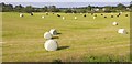
Freshly cut fields
Freshly cut fields at Townhead of Greenlaw.
Image: © Colin Kinnear
Taken: 14 Jun 2020
0.15 miles
9
The Paddy
Trackbed of the Portpatrick and Wigtown Railway which used to run to the ferries at Stranraer.
Image: © Richard Webb
Taken: 14 Jun 2022
0.16 miles
10
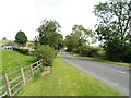
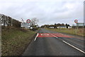
Road past Monks Muir
Monks Muir is a converted smithy.
Image: © James Bell
Taken: 1 Sep 2010
0.17 miles