IMAGES TAKEN NEAR TO
Pennywell, CASTLE DOUGLAS, DG7 2LE
Introduction
This page details the photographs taken nearby to Pennywell, DG7 2LE by members of the Geograph project.
The Geograph project started in 2005 with the aim of publishing, organising and preserving representative images for every square kilometre of Great Britain, Ireland and the Isle of Man.

There are currently over 7.5m images from over14,400 individuals and you can help contribute to the project by visiting https://www.geograph.org.uk
Image Map
Images are licensed for reuse under creativecommons.org/licenses/by-sa/2.0
Notes
- Clicking on the map will re-center to the selected point.
- The higher the marker number, the further away the image location is from the centre of the postcode.
Image Listing (49 Images Found)
Images are licensed for reuse under creativecommons.org/licenses/by-sa/2.0
Image
Details
Distance
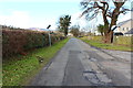
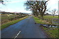
1
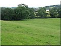
Looking back to Gatehouse
Pasture in the valley of the Water of Fleet, from the road to the cemetery.
Image: © M J Richardson
Taken: 30 Jul 2009
0.06 miles
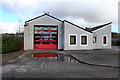
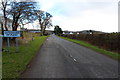
4
Fire Station Car Park, Gatehouse of Fleet
Image: © Billy McCrorie
Taken: 4 Mar 2015
0.10 miles
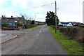
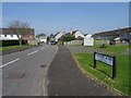
10
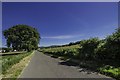
Old Military Road to Gatehouse of Fleet
Taken near to Blackloch Farm, the B796 to Gatehouse.
Image: © Andy Farrington
Taken: 18 Jun 2014
0.16 miles