IMAGES TAKEN NEAR TO
Gatehouse Of Fleet, CASTLE DOUGLAS, DG7 2HA
Introduction
This page details the photographs taken nearby to DG7 2HA by members of the Geograph project.
The Geograph project started in 2005 with the aim of publishing, organising and preserving representative images for every square kilometre of Great Britain, Ireland and the Isle of Man.

There are currently over 7.5m images from over14,400 individuals and you can help contribute to the project by visiting https://www.geograph.org.uk
Image Map
Images are licensed for reuse under creativecommons.org/licenses/by-sa/2.0
Notes
- Clicking on the map will re-center to the selected point.
- The higher the marker number, the further away the image location is from the centre of the postcode.
Image Listing (6 Images Found)
Images are licensed for reuse under creativecommons.org/licenses/by-sa/2.0
Image
Details
Distance
1
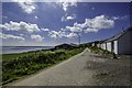
Bardistrane Farm
View along this small road which sits above the main A75, looking across to Wigtown Bay.
Image: © Andy Farrington
Taken: 3 Jun 2014
0.10 miles
2
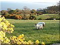
View from Bardristane Forge, Irish Sea, Isle of Man in distance
Image: © Peter Barr
Taken: 1 May 2007
0.11 miles
3
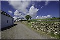
Farm at Bardistrane
Main drive and entrance to the farm found by a small road above the A75.
Image: © Andy Farrington
Taken: 3 Jun 2014
0.11 miles
4
Barn at Bardistrane
Great views past the barn on the day I visited, looking to Eggerness Point at Garlieston centre, and the Isle of Man which is about 30 miles away as the crow flies.
Image: © Andy Farrington
Taken: 3 Jun 2014
0.12 miles
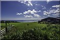
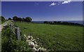
5

Fields by Bardistrane
Great view on a clear day from the farm above the A75 with the Machars to the right of picture and the Isle of Man in the distance.
Image: © Andy Farrington
Taken: 3 Jun 2014
0.14 miles
6
Bardistrane
View from this small road above the A75 looking over fields by the farm to Fleet Bay.
Image: © Andy Farrington
Taken: 3 Jun 2014
0.16 miles