IMAGES TAKEN NEAR TO
Gatehouse Of Fleet, CASTLE DOUGLAS, DG7 2DS
Introduction
This page details the photographs taken nearby to DG7 2DS by members of the Geograph project.
The Geograph project started in 2005 with the aim of publishing, organising and preserving representative images for every square kilometre of Great Britain, Ireland and the Isle of Man.

There are currently over 7.5m images from over14,400 individuals and you can help contribute to the project by visiting https://www.geograph.org.uk
Image Map (Loading...)


Getting Data...Please wait
Leaflet Map data © OpenStreetMap
Images are licensed for reuse under creativecommons.org/licenses/by-sa/2.0
Notes
- Clicking on the map will re-center to the selected point.
- The higher the marker number, the further away the image location is from the centre of the postcode.
Image Listing (16 Images Found)
Images are licensed for reuse under creativecommons.org/licenses/by-sa/2.0
Image
Details
Distance
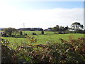
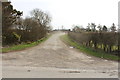
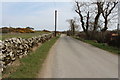
2
Boreland of Girthon
The entrance to what is a substantial farm.
Image: © M J Richardson
Taken: 4 Jul 2019
0.03 miles
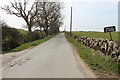
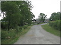
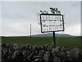
6
Boreland of Girthon sign
The eye catching sign is located opposite the driveway to Boreland of Girthon Farm.
Image: © Neil Theasby
Taken: 13 Aug 2017
0.09 miles
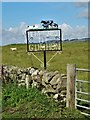
8
Boreland of Girthon
Attractive farm entrance sign near Sandgreen. The hills in the distance are Cairnharrow, Barholm Hill and Ben John, inland from Carsluith.
Image: © M J Richardson
Taken: 4 Jul 2019
0.10 miles