IMAGES TAKEN NEAR TO
Gatehouse Of Fleet, CASTLE DOUGLAS, DG7 2DN
Introduction
This page details the photographs taken nearby to DG7 2DN by members of the Geograph project.
The Geograph project started in 2005 with the aim of publishing, organising and preserving representative images for every square kilometre of Great Britain, Ireland and the Isle of Man.

There are currently over 7.5m images from over14,400 individuals and you can help contribute to the project by visiting https://www.geograph.org.uk
Image Map
Images are licensed for reuse under creativecommons.org/licenses/by-sa/2.0
Notes
- Clicking on the map will re-center to the selected point.
- The higher the marker number, the further away the image location is from the centre of the postcode.
Image Listing (12 Images Found)
Images are licensed for reuse under creativecommons.org/licenses/by-sa/2.0
Image
Details
Distance


10

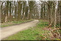
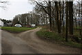
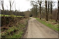
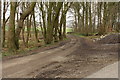
Cally Mains Wood
Mixed woodland by the track linking Cally Mains with Sandgreen, which just cuts across the corner of the square.
Image: © Callum Black
Taken: 2 Jan 2008
0.17 miles