IMAGES TAKEN NEAR TO
Gatehouse Of Fleet, CASTLE DOUGLAS, DG7 2DH
Introduction
This page details the photographs taken nearby to DG7 2DH by members of the Geograph project.
The Geograph project started in 2005 with the aim of publishing, organising and preserving representative images for every square kilometre of Great Britain, Ireland and the Isle of Man.

There are currently over 7.5m images from over14,400 individuals and you can help contribute to the project by visiting https://www.geograph.org.uk
Image Map (Loading...)


Getting Data...Please wait
Leaflet Map data © OpenStreetMap
Images are licensed for reuse under creativecommons.org/licenses/by-sa/2.0
Notes
- Clicking on the map will re-center to the selected point.
- The higher the marker number, the further away the image location is from the centre of the postcode.
Image Listing (172 Images Found)
Images are licensed for reuse under creativecommons.org/licenses/by-sa/2.0
Image
Details
Distance
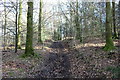
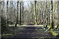
4
Bush Burn looking east
This view is taken from a small bridge in Cally Woods.
Image: © Ann Cook
Taken: 26 Apr 2010
0.06 miles
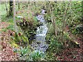
6
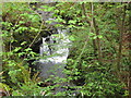
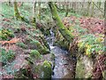
Small waterfall on the Bush Burn, in Cally Woods
This pretty little waterfall gets harder to see as the leaves grow bigger on the trees.
Image: © Ann Cook
Taken: 26 Apr 2009
0.06 miles
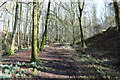
8
A bridge over Bush Burn
This is on the path to Robber's Gate.
Image: © Ann Cook
Taken: 10 May 2011
0.07 miles
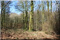
9
Bush Burn looking west
The bridge carrying the track to Dalavan can be seen through the trees.
Image: © Ann Cook
Taken: 26 Apr 2010
0.07 miles
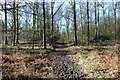
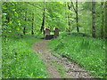
10
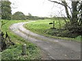
Track to Dalavan
The signpost reads "Dalavan".
Image: © Ann Cook
Taken: 26 Apr 2010
0.07 miles