IMAGES TAKEN NEAR TO
Laurieston Park, CASTLE DOUGLAS, DG7 2BF
Introduction
This page details the photographs taken nearby to Laurieston Park, DG7 2BF by members of the Geograph project.
The Geograph project started in 2005 with the aim of publishing, organising and preserving representative images for every square kilometre of Great Britain, Ireland and the Isle of Man.

There are currently over 7.5m images from over14,400 individuals and you can help contribute to the project by visiting https://www.geograph.org.uk
Image Map (Loading...)


Getting Data...Please wait
Leaflet Map data © OpenStreetMap
Images are licensed for reuse under creativecommons.org/licenses/by-sa/2.0
Notes
- Clicking on the map will re-center to the selected point.
- The higher the marker number, the further away the image location is from the centre of the postcode.
Image Listing (63 Images Found)
Images are licensed for reuse under creativecommons.org/licenses/by-sa/2.0
Image
Details
Distance
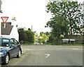
3
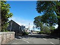
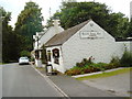
Laurieston Village
Attractive and well-maintained properties in Laurieston village, viewed at the crossroads.
Image: © Mary and Angus Hogg
Taken: 19 Jun 2013
0.07 miles
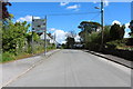
6
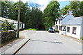
Road to Gatehouse of Fleet at Laurieston
Image: © Billy McCrorie
Taken: 21 May 2014
0.09 miles
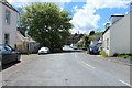
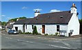
10
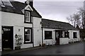
The Laurie Inn
The Laurie Inn, Laurieston.
Image: © Colin Kinnear
Taken: 21 Dec 2008
0.13 miles