IMAGES TAKEN NEAR TO
Auchencairn, CASTLE DOUGLAS, DG7 1RL
Introduction
This page details the photographs taken nearby to DG7 1RL by members of the Geograph project.
The Geograph project started in 2005 with the aim of publishing, organising and preserving representative images for every square kilometre of Great Britain, Ireland and the Isle of Man.

There are currently over 7.5m images from over14,400 individuals and you can help contribute to the project by visiting https://www.geograph.org.uk
Image Map
Images are licensed for reuse under creativecommons.org/licenses/by-sa/2.0
Notes
- Clicking on the map will re-center to the selected point.
- The higher the marker number, the further away the image location is from the centre of the postcode.
Image Listing (2 Images Found)
Images are licensed for reuse under creativecommons.org/licenses/by-sa/2.0
Image
Details
Distance
2
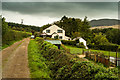
Glenhead, Auchencairn
View northwest along track to Glenhead Farm. In the distance is Hass Farm nestling under Dungarry and Bentudor hills.
Image: © Chris Newman
Taken: 24 Mar 2008
0.21 miles