IMAGES TAKEN NEAR TO
CASTLE DOUGLAS, DG7 1RE
Introduction
This page details the photographs taken nearby to DG7 1RE by members of the Geograph project.
The Geograph project started in 2005 with the aim of publishing, organising and preserving representative images for every square kilometre of Great Britain, Ireland and the Isle of Man.

There are currently over 7.5m images from over14,400 individuals and you can help contribute to the project by visiting https://www.geograph.org.uk
Image Map
Images are licensed for reuse under creativecommons.org/licenses/by-sa/2.0
Notes
- Clicking on the map will re-center to the selected point.
- The higher the marker number, the further away the image location is from the centre of the postcode.
Image Listing (5 Images Found)
Images are licensed for reuse under creativecommons.org/licenses/by-sa/2.0
Image
Details
Distance
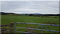
2
Grazing land at Culnaightrie
Grazing land at Culnaightrie Farm near to Auchencairn.
Image: © Colin Kinnear
Taken: 16 Dec 2010
0.09 miles
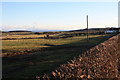
3
Farmland West of Auchencairn
Open fields near to Auchencairn.
Image: © Peter Mackenzie
Taken: 15 Sep 2018
0.14 miles
4
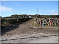
Culnaightrie, Auchencairn
Culnaightrie Farm from the Auchenleck lane at Culnaightrie Cottage corner. Behind the farm are the heights of Suie Hill.
Image: © Chris Newman
Taken: 4 Mar 2008
0.22 miles
5
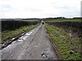
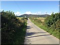
Auchenleck Junction, Auchencairn
View down the Auchenleck-Culnaightrie lane with a lone quadbiker.
Image: © Chris Newman
Taken: 4 Mar 2008
0.23 miles