IMAGES TAKEN NEAR TO
CASTLE DOUGLAS, DG7 1QH
Introduction
This page details the photographs taken nearby to DG7 1QH by members of the Geograph project.
The Geograph project started in 2005 with the aim of publishing, organising and preserving representative images for every square kilometre of Great Britain, Ireland and the Isle of Man.

There are currently over 7.5m images from over14,400 individuals and you can help contribute to the project by visiting https://www.geograph.org.uk
Image Map (Loading...)


Getting Data...Please wait
Leaflet Map data © OpenStreetMap
Images are licensed for reuse under creativecommons.org/licenses/by-sa/2.0
Notes
- Clicking on the map will re-center to the selected point.
- The higher the marker number, the further away the image location is from the centre of the postcode.
Image Listing (18 Images Found)
Images are licensed for reuse under creativecommons.org/licenses/by-sa/2.0
Image
Details
Distance
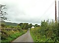
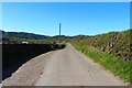
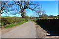
1

Roadway towards Redliggate
Old Douganhill can be seen in background.
Image: © James Bell
Taken: 3 Sep 2010
0.01 miles
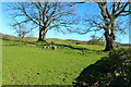
3
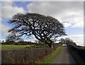
Wind Beaten Tree
An old gnarled tree bent by the strong winds blown in from the coast.
Image: © Colin Kinnear
Taken: 22 Feb 2009
0.09 miles
5
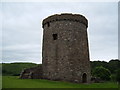
Orchardton Tower
Historic Scotland property
Image: © Alison Stamp
Taken: 18 Jun 2005
0.09 miles
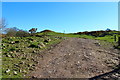
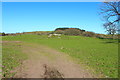
9
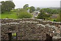
Orchardton Mains
From the top of the tower.
Image: © Mick Garratt
Taken: 20 Aug 2010
0.21 miles