IMAGES TAKEN NEAR TO
Palnackie, CASTLE DOUGLAS, DG7 1PW
Introduction
This page details the photographs taken nearby to DG7 1PW by members of the Geograph project.
The Geograph project started in 2005 with the aim of publishing, organising and preserving representative images for every square kilometre of Great Britain, Ireland and the Isle of Man.

There are currently over 7.5m images from over14,400 individuals and you can help contribute to the project by visiting https://www.geograph.org.uk
Image Map (Loading...)


Getting Data...Please wait
Leaflet Map data © OpenStreetMap
Images are licensed for reuse under creativecommons.org/licenses/by-sa/2.0
Notes
- Clicking on the map will re-center to the selected point.
- The higher the marker number, the further away the image location is from the centre of the postcode.
Image Listing (44 Images Found)
Images are licensed for reuse under creativecommons.org/licenses/by-sa/2.0
Image
Details
Distance

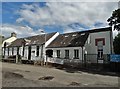
5
Palnackie Primary School
South of the village of Palnackie.
Image: © Russel Wills
Taken: 16 Jun 2022
0.01 miles
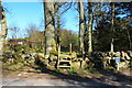
9
Path and Stile
Woodland path and stile next to the primary school.
Image: © Colin Kinnear
Taken: 30 May 2020
0.05 miles
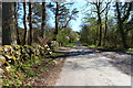
10
Palnackie
Entering the village from the A711.
Image: © Andy Farrington
Taken: 4 Jun 2012
0.08 miles