IMAGES TAKEN NEAR TO
CASTLE DOUGLAS, DG7 1PD
Introduction
This page details the photographs taken nearby to DG7 1PD by members of the Geograph project.
The Geograph project started in 2005 with the aim of publishing, organising and preserving representative images for every square kilometre of Great Britain, Ireland and the Isle of Man.

There are currently over 7.5m images from over14,400 individuals and you can help contribute to the project by visiting https://www.geograph.org.uk
Image Map
Images are licensed for reuse under creativecommons.org/licenses/by-sa/2.0
Notes
- Clicking on the map will re-center to the selected point.
- The higher the marker number, the further away the image location is from the centre of the postcode.
Image Listing (8 Images Found)
Images are licensed for reuse under creativecommons.org/licenses/by-sa/2.0
Image
Details
Distance
1
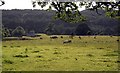
Broomisle
Looking across the fields to Broomisle.
Image: © Colin Kinnear
Taken: 20 Jun 2008
0.01 miles
4

Keeper's Cottage, Munches Estate.
Formerly known as Colehole.
Image: © James Bell
Taken: 13 Jul 2003
0.14 miles
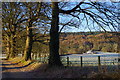
5
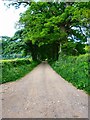
Broomisle
Track to the dwelling off the A711.
Image: © Andy Farrington
Taken: 4 Jun 2012
0.15 miles
6
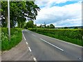
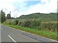
A711 to Dalbeattie
View of the road from Broomisle.
Image: © Andy Farrington
Taken: 4 Jun 2012
0.22 miles
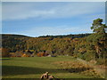
7

A711 to Palnackie
View along this road by Broomisle.
Image: © Andy Farrington
Taken: 4 Jun 2012
0.23 miles