IMAGES TAKEN NEAR TO
Dunmuir Road, CASTLE DOUGLAS, DG7 1LQ
Introduction
This page details the photographs taken nearby to Dunmuir Road, DG7 1LQ by members of the Geograph project.
The Geograph project started in 2005 with the aim of publishing, organising and preserving representative images for every square kilometre of Great Britain, Ireland and the Isle of Man.

There are currently over 7.5m images from over14,400 individuals and you can help contribute to the project by visiting https://www.geograph.org.uk
Image Map
Images are licensed for reuse under creativecommons.org/licenses/by-sa/2.0
Notes
- Clicking on the map will re-center to the selected point.
- The higher the marker number, the further away the image location is from the centre of the postcode.
Image Listing (16 Images Found)
Images are licensed for reuse under creativecommons.org/licenses/by-sa/2.0
Image
Details
Distance
6
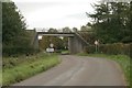
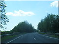
Bridge over the B795
The A75 crosses the B795 as it enters Castle Douglas.
Image: © Richard Sutcliffe
Taken: 11 Oct 2016
0.18 miles
7
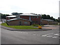
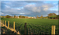
Garden Hill Primary Care Centre
Sunday morning at the new, unpretentious but efficient Primary Care Centre for the Castle Douglas area.
Image: © Chris Newman
Taken: 8 Jun 2008
0.18 miles
9
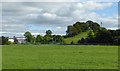
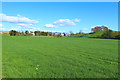
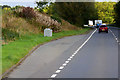
Towards Dunmuir Hill
A communications mast on Dunmuir Hill, on the edge of Castle Douglas.
Image: © Mary and Angus Hogg
Taken: 19 Sep 2016
0.20 miles
10
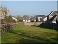
Gap on Ernespie Road
A gap in the row of houses, beyond Rob Place.
Image: © Richard Webb
Taken: 22 Apr 2019
0.21 miles