IMAGES TAKEN NEAR TO
Marle Street, CASTLE DOUGLAS, DG7 1ET
Introduction
This page details the photographs taken nearby to Marle Street, DG7 1ET by members of the Geograph project.
The Geograph project started in 2005 with the aim of publishing, organising and preserving representative images for every square kilometre of Great Britain, Ireland and the Isle of Man.

There are currently over 7.5m images from over14,400 individuals and you can help contribute to the project by visiting https://www.geograph.org.uk
Image Map (Loading...)


Getting Data...Please wait
Leaflet Map data © OpenStreetMap
Images are licensed for reuse under creativecommons.org/licenses/by-sa/2.0
Notes
- Clicking on the map will re-center to the selected point.
- The higher the marker number, the further away the image location is from the centre of the postcode.
Image Listing (317 Images Found)
Images are licensed for reuse under creativecommons.org/licenses/by-sa/2.0
Image
Details
Distance
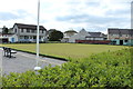
5
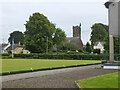
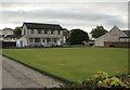
Bowling green, Castle Douglas
A bowling green on the south side of the town.
Image: © Jim Barton
Taken: 1 Sep 2024
0.03 miles
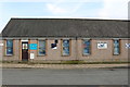
9
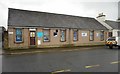
Air Training Corps, King Street, Castle Douglas
Home to the 2329 (Castle Douglas) Squadron of the Air Training Corps.
Image: © Richard Sutcliffe
Taken: 23 Oct 2017
0.05 miles