IMAGES TAKEN NEAR TO
Burghfield Road, CASTLE DOUGLAS, DG7 1BQ
Introduction
This page details the photographs taken nearby to Burghfield Road, DG7 1BQ by members of the Geograph project.
The Geograph project started in 2005 with the aim of publishing, organising and preserving representative images for every square kilometre of Great Britain, Ireland and the Isle of Man.

There are currently over 7.5m images from over14,400 individuals and you can help contribute to the project by visiting https://www.geograph.org.uk
Image Map
Images are licensed for reuse under creativecommons.org/licenses/by-sa/2.0
Notes
- Clicking on the map will re-center to the selected point.
- The higher the marker number, the further away the image location is from the centre of the postcode.
Image Listing (127 Images Found)
Images are licensed for reuse under creativecommons.org/licenses/by-sa/2.0
Image
Details
Distance
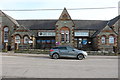
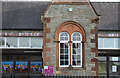
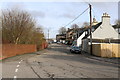
2

Urban Green Space
Built on the old railway sidings. Looking towards the housing on Burghfield Road.
Image: © Mick Garratt
Taken: 19 Aug 2010
0.11 miles
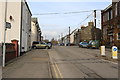
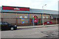
7
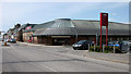
Wilko supermarket, Castle Douglas
On Cotton Street.
Image: © Richard Sutcliffe
Taken: 17 May 2018
0.15 miles