IMAGES TAKEN NEAR TO
Abercromby Road, CASTLE DOUGLAS, DG7 1BA
Introduction
This page details the photographs taken nearby to Abercromby Road, DG7 1BA by members of the Geograph project.
The Geograph project started in 2005 with the aim of publishing, organising and preserving representative images for every square kilometre of Great Britain, Ireland and the Isle of Man.

There are currently over 7.5m images from over14,400 individuals and you can help contribute to the project by visiting https://www.geograph.org.uk
Image Map (Loading...)


Getting Data...Please wait
Leaflet Map data © OpenStreetMap
Images are licensed for reuse under creativecommons.org/licenses/by-sa/2.0
Notes
- Clicking on the map will re-center to the selected point.
- The higher the marker number, the further away the image location is from the centre of the postcode.
Image Listing (41 Images Found)
Images are licensed for reuse under creativecommons.org/licenses/by-sa/2.0
Image
Details
Distance

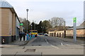
2
Castle Douglas St. Andrew Street railway station (site), Dumfries & Galloway
Opened in 1864 by the Kirkcudbright Railway, soon to become part of the Glasgow & South Western Railway, on the line from Castle Douglas to Kirkcudbright. This temporary station closed in 1867 when the line gained access to the main station in Castle Douglas. The delay had been caused by the need to reconstruct the junction with the "main" line which had apparently not been up to Board of Trade standards.
View south west towards Bridge of Dee and Kirkcudbright from what is now Abercrombie Road bridge. The only evidence of the station is what appears to be a blocked-up entrance on the bridge parapet (not in view).
Image: © Nigel Thompson
Taken: 7 May 2019
0.13 miles
3
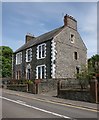
House on Abercromby Road, Castle Douglas
Numbers 15A and 15B Abercromby Street.
Image: © Richard Sutcliffe
Taken: 17 May 2018
0.15 miles
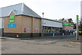
4

Trinity Houses, Abercromby Road, Castle Douglas
Four residential properties in the converted former U P Church.
Image: © Richard Sutcliffe
Taken: 17 May 2018
0.15 miles
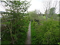
5
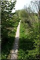
Old railway line
The trackbed of the former Kirkcudbright Railway, which was a branch line from Castle Douglas to Kirkcudbright opened in 1864 and closed in 1965. Now a footpath.
Image: © Richard Sutcliffe
Taken: 17 May 2018
0.17 miles
6
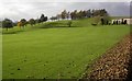
Golf Course
Castle Douglas golf course.
Image: © Colin Kinnear
Taken: 26 Oct 2008
0.18 miles

10
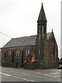
St John the Evangelist RC Church
At the junction of Abercromby Road and Cotton Street. The church dates from 1867 and is Category C listed, but is now closed due to structural problems.
Image: © Richard Sutcliffe
Taken: 23 Oct 2017
0.20 miles