IMAGES TAKEN NEAR TO
KIRKCUDBRIGHT, DG6 4XS
Introduction
This page details the photographs taken nearby to DG6 4XS by members of the Geograph project.
The Geograph project started in 2005 with the aim of publishing, organising and preserving representative images for every square kilometre of Great Britain, Ireland and the Isle of Man.

There are currently over 7.5m images from over14,400 individuals and you can help contribute to the project by visiting https://www.geograph.org.uk
Image Map
Images are licensed for reuse under creativecommons.org/licenses/by-sa/2.0
Notes
- Clicking on the map will re-center to the selected point.
- The higher the marker number, the further away the image location is from the centre of the postcode.
Image Listing (6 Images Found)
Images are licensed for reuse under creativecommons.org/licenses/by-sa/2.0
Image
Details
Distance
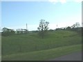
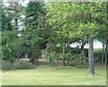
1
Little Sypland Cottages
Looking along this access road down to Hartburn Farm.
Image: © Andy Farrington
Taken: 4 Jun 2014
0.00 miles
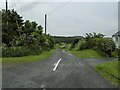
2
Little Sypland Farm
View of the B727 in the direction of Kirkcudbright.
Image: © Andy Farrington
Taken: 4 Jun 2014
0.04 miles
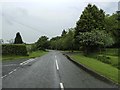
3
Little Sypland
View of the B727 on its way to Gelston.
Image: © Andy Farrington
Taken: 4 Jun 2014
0.06 miles
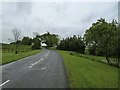
5
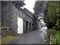
Little Sypland
Outbuildings at Little Sypland Farm.
Image: © Colin Kinnear
Taken: 13 Sep 2008
0.11 miles