IMAGES TAKEN NEAR TO
KIRKCUDBRIGHT, DG6 4XP
Introduction
This page details the photographs taken nearby to DG6 4XP by members of the Geograph project.
The Geograph project started in 2005 with the aim of publishing, organising and preserving representative images for every square kilometre of Great Britain, Ireland and the Isle of Man.

There are currently over 7.5m images from over14,400 individuals and you can help contribute to the project by visiting https://www.geograph.org.uk
Image Map
Images are licensed for reuse under creativecommons.org/licenses/by-sa/2.0
Notes
- Clicking on the map will re-center to the selected point.
- The higher the marker number, the further away the image location is from the centre of the postcode.
Image Listing (6 Images Found)
Images are licensed for reuse under creativecommons.org/licenses/by-sa/2.0
Image
Details
Distance
1
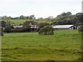
Buckland Plants
Nursery at Whinnieliggate
Image: © Leslie Barrie
Taken: 28 Sep 2013
0.02 miles
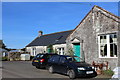
2
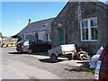
Old School, Whinnieliggate
Former school, now a successful nursery in the Buckland area
Image: © Helen Bowick
Taken: 29 Aug 2010
0.02 miles
3
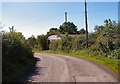
Former Village Hall at Whinnieliggate
Once the centre of a community, now disused.
Image: © Helen Bowick
Taken: 29 Aug 2010
0.05 miles