IMAGES TAKEN NEAR TO
KIRKCUDBRIGHT, DG6 4XL
Introduction
This page details the photographs taken nearby to DG6 4XL by members of the Geograph project.
The Geograph project started in 2005 with the aim of publishing, organising and preserving representative images for every square kilometre of Great Britain, Ireland and the Isle of Man.

There are currently over 7.5m images from over14,400 individuals and you can help contribute to the project by visiting https://www.geograph.org.uk
Image Map
Images are licensed for reuse under creativecommons.org/licenses/by-sa/2.0
Notes
- Clicking on the map will re-center to the selected point.
- The higher the marker number, the further away the image location is from the centre of the postcode.
Image Listing (10 Images Found)
Images are licensed for reuse under creativecommons.org/licenses/by-sa/2.0
Image
Details
Distance

2
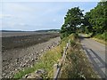
The Lake road
Tide's out at the mouth of Manxman's Lake.
Image: © Richard Webb
Taken: 20 Jul 2013
0.05 miles
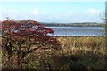
3

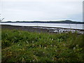
The coast from the Lake
High tide at the Lake near to Mutehill.
Image: © Peter Mackenzie
Taken: 23 Aug 2017
0.05 miles
4
Public path leading to Kirkcudbright Lifeboat Station
Image: © Helen Bowick
Taken: 28 Aug 2010
0.06 miles
6
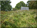
Corrugated iron shed sited near Parkgate
Image: © Phil Catterall
Taken: 29 Sep 2007
0.15 miles
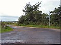
8

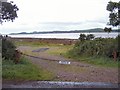
The track near to Parkgate
The track leads to the lifeboat station.
Image: © Peter Mackenzie
Taken: 23 Aug 2017
0.19 miles
9
Layby at The Lake Kirkcudbright
Others not allowed
Image: © Helen Bowick
Taken: 28 Aug 2010
0.23 miles
10

Parkgate cottage
A lovely house on the track that leads to the lifeboat station.
Image: © Peter Mackenzie
Taken: 23 Aug 2017
0.24 miles