IMAGES TAKEN NEAR TO
KIRKCUDBRIGHT, DG6 4XG
Introduction
This page details the photographs taken nearby to DG6 4XG by members of the Geograph project.
The Geograph project started in 2005 with the aim of publishing, organising and preserving representative images for every square kilometre of Great Britain, Ireland and the Isle of Man.

There are currently over 7.5m images from over14,400 individuals and you can help contribute to the project by visiting https://www.geograph.org.uk
Image Map
Images are licensed for reuse under creativecommons.org/licenses/by-sa/2.0
Notes
- Clicking on the map will re-center to the selected point.
- The higher the marker number, the further away the image location is from the centre of the postcode.
Image Listing (5 Images Found)
Images are licensed for reuse under creativecommons.org/licenses/by-sa/2.0
Image
Details
Distance
1
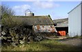
Grange Farm
Outbuildings on Grange Farm.
Image: © Colin Kinnear
Taken: 12 Mar 2008
0.03 miles
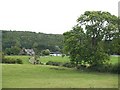
3
Across the fields to Grange House, Kirkcudbright
Image: © James Bell
Taken: Unknown
0.08 miles
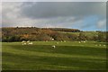
4
Trees lining the road near Grange Farm, Muthill
One of the few bits of this area of the countryside that wasn't flying a red flag that day - most of this peninsula (if you can call it that) is MOD training area and I didn't want to get shot as a spy/terrorist, so this is as exciting as the photos got!
Image: © Kirsty Smith
Taken: 16 Oct 2005
0.11 miles
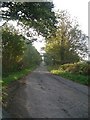
5
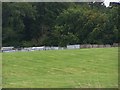
Pheasant rearing cages
Part of the organisation required to provide pheasants for a shooting estate
Image: © Helen Bowick
Taken: 28 Aug 2010
0.12 miles