IMAGES TAKEN NEAR TO
KIRKCUDBRIGHT, DG6 4UY
Introduction
This page details the photographs taken nearby to DG6 4UY by members of the Geograph project.
The Geograph project started in 2005 with the aim of publishing, organising and preserving representative images for every square kilometre of Great Britain, Ireland and the Isle of Man.

There are currently over 7.5m images from over14,400 individuals and you can help contribute to the project by visiting https://www.geograph.org.uk
Image Map
Images are licensed for reuse under creativecommons.org/licenses/by-sa/2.0
Notes
- Clicking on the map will re-center to the selected point.
- The higher the marker number, the further away the image location is from the centre of the postcode.
Image Listing (15 Images Found)
Images are licensed for reuse under creativecommons.org/licenses/by-sa/2.0
Image
Details
Distance
1
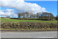
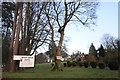
Arden House Hotel
The Arden House Hotel on the northern edge of Kirkcudbright.
Image: © Colin Kinnear
Taken: 22 Nov 2010
0.05 miles
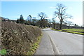
3
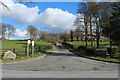
Road to High Boreland Farm and Arden Hotel
Image: © Billy McCrorie
Taken: 3 Mar 2014
0.12 miles
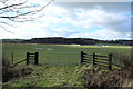
4
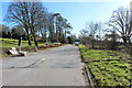
Road to Kirkcudbright at Arden House Hotel
Image: © Billy McCrorie
Taken: 3 Mar 2014
0.16 miles
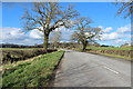
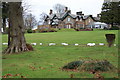
6
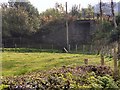
Bridge over former railway
Bridge over what used to be the branch line from Castle Douglas to Kirkcudbright. Axed by Beeching.
Image: © Helen Bowick
Taken: 10 Oct 2010
0.17 miles
7
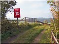
Ex railway bridge near The Carse
Bridge crossing the railway line axed by Beeching.
Image: © Helen Bowick
Taken: 10 Oct 2010
0.17 miles