IMAGES TAKEN NEAR TO
Borgue, KIRKCUDBRIGHT, DG6 4UA
Introduction
This page details the photographs taken nearby to DG6 4UA by members of the Geograph project.
The Geograph project started in 2005 with the aim of publishing, organising and preserving representative images for every square kilometre of Great Britain, Ireland and the Isle of Man.

There are currently over 7.5m images from over14,400 individuals and you can help contribute to the project by visiting https://www.geograph.org.uk
Image Map
Images are licensed for reuse under creativecommons.org/licenses/by-sa/2.0
Notes
- Clicking on the map will re-center to the selected point.
- The higher the marker number, the further away the image location is from the centre of the postcode.
Image Listing (18 Images Found)
Images are licensed for reuse under creativecommons.org/licenses/by-sa/2.0
Image
Details
Distance
1
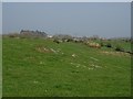
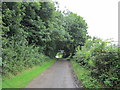
Field, Kirkandrews
Rock seldom far from the surface on the Borgue Peninsula.
Image: © Richard Webb
Taken: 21 Apr 2019
0.05 miles
2
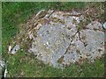
Cup and ring stone
Cup and ring stone located near telegraph pole near road
Image: © rod collier
Taken: 15 Apr 2010
0.06 miles
5
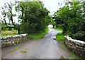
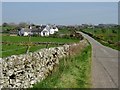
Roberton Bridge
Roberton Bridge carrying the B727.
Image: © Chris McAuley
Taken: 6 Aug 2012
0.17 miles
6

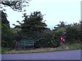
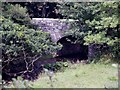
Rustic Gate near Kirkandrews.
This gate across Pulwhirrin Burn is at Roberton Bridge in Borgue parish.
Image: © James Bell
Taken: 16 Aug 2010
0.19 miles
7
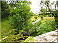
Pulwhirrin Burn
Pulwhirrin Burn from Roberton Bridge.
Image: © Chris McAuley
Taken: 6 Aug 2012
0.19 miles
10
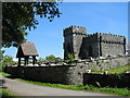
Kirkandrews - old church
The beautiful old Kirkandrews Church is still in use today.
Image: © Madeleine Kirk
Taken: 22 Jun 2004
0.24 miles