IMAGES TAKEN NEAR TO
Borgue, KIRKCUDBRIGHT, DG6 4TW
Introduction
This page details the photographs taken nearby to DG6 4TW by members of the Geograph project.
The Geograph project started in 2005 with the aim of publishing, organising and preserving representative images for every square kilometre of Great Britain, Ireland and the Isle of Man.

There are currently over 7.5m images from over14,400 individuals and you can help contribute to the project by visiting https://www.geograph.org.uk
Image Map
Images are licensed for reuse under creativecommons.org/licenses/by-sa/2.0
Notes
- Clicking on the map will re-center to the selected point.
- The higher the marker number, the further away the image location is from the centre of the postcode.
Image Listing (10 Images Found)
Images are licensed for reuse under creativecommons.org/licenses/by-sa/2.0
Image
Details
Distance
1
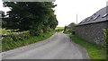
Minor road at Clauchendolly
The minor road at Clauchendolly farm.
Image: © Peter Mackenzie
Taken: 22 Aug 2017
0.04 miles
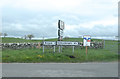
2
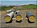
Cluden to Brighouse gas pipeline construction
This 50 kilometre pipeline is being constructed for Gas Networks Ireland at a cost of some 94 million euros.
Image: © Neil Theasby
Taken: 13 Aug 2017
0.06 miles
4

Road to Brighouse Bay near Clauchendolly
Image: © Billy McCrorie
Taken: 27 Jun 2014
0.12 miles
5
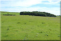
Smithy Plantation
An area of native woodland near Clauchendolly.
Image: © Colin Kinnear
Taken: 18 Mar 2021
0.14 miles
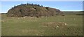
7

Road to Kirkcudbright near Smithy Plantation
Image: © Billy McCrorie
Taken: 27 Jun 2014
0.16 miles


