IMAGES TAKEN NEAR TO
KIRKCUDBRIGHT, DG6 4TJ
Introduction
This page details the photographs taken nearby to DG6 4TJ by members of the Geograph project.
The Geograph project started in 2005 with the aim of publishing, organising and preserving representative images for every square kilometre of Great Britain, Ireland and the Isle of Man.

There are currently over 7.5m images from over14,400 individuals and you can help contribute to the project by visiting https://www.geograph.org.uk
Image Map
Images are licensed for reuse under creativecommons.org/licenses/by-sa/2.0
Notes
- Clicking on the map will re-center to the selected point.
- The higher the marker number, the further away the image location is from the centre of the postcode.
Image Listing (9 Images Found)
Images are licensed for reuse under creativecommons.org/licenses/by-sa/2.0
Image
Details
Distance


3
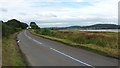
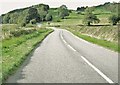
The road near to Bishopton
The B727 heading towards Kirkcudbright, (which is visible in the distance.)
Image: © Peter Mackenzie
Taken: 22 Aug 2017
0.13 miles
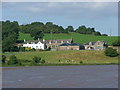
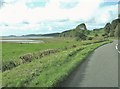
5
Shoreline, Bishopton
Kirkcudbright in the distance, across the Dee estuary.
Image: © Richard Webb
Taken: 21 Apr 2019
0.20 miles
6
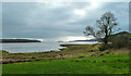
Shore by the River Dee
View south to Kirkcudbright Bay with Little Ross on the far horizon.
Image: © Andy Farrington
Taken: 22 Jan 2014
0.20 miles
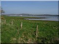
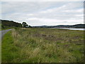
8
Fields beside the River Dee
This view is taken from the B727. Far out, on the horizon, Little Ross can be seen.
Image: © Ann Cook
Taken: 18 Sep 2010
0.22 miles
9
Banks of the Dee estuary near to Kirkcudbright
Image: © Phil Catterall
Taken: 28 Sep 2007
0.24 miles