IMAGES TAKEN NEAR TO
Borgue, KIRKCUDBRIGHT, DG6 4SX
Introduction
This page details the photographs taken nearby to DG6 4SX by members of the Geograph project.
The Geograph project started in 2005 with the aim of publishing, organising and preserving representative images for every square kilometre of Great Britain, Ireland and the Isle of Man.

There are currently over 7.5m images from over14,400 individuals and you can help contribute to the project by visiting https://www.geograph.org.uk
Image Map
Images are licensed for reuse under creativecommons.org/licenses/by-sa/2.0
Notes
- Clicking on the map will re-center to the selected point.
- The higher the marker number, the further away the image location is from the centre of the postcode.
Image Listing (7 Images Found)
Images are licensed for reuse under creativecommons.org/licenses/by-sa/2.0
Image
Details
Distance
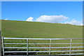
1
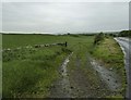
Doon of Boreland
View of the A755 down to Kirkcudbright with a farm track off left to the Doon of Boreland.
Image: © Andy Farrington
Taken: 4 Jun 2014
0.20 miles
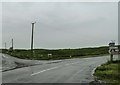
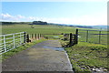
3
Road to Gatehouse of Fleet at Boreland of Borgue
Image: © Billy McCrorie
Taken: 3 Mar 2014
0.22 miles
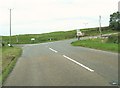
4
Turn for High Borgue
Seen here off the A755 which runs between Kirkcudbright and the main A75.
Image: © Andy Farrington
Taken: 4 Jun 2014
0.22 miles
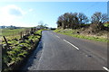
7
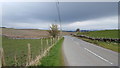
The road at High Borgue
The road passing High Borgue on its approach to the A755.
Image: © Peter Mackenzie
Taken: 12 Apr 2018
0.25 miles