IMAGES TAKEN NEAR TO
Borgue, KIRKCUDBRIGHT, DG6 4SH
Introduction
This page details the photographs taken nearby to DG6 4SH by members of the Geograph project.
The Geograph project started in 2005 with the aim of publishing, organising and preserving representative images for every square kilometre of Great Britain, Ireland and the Isle of Man.

There are currently over 7.5m images from over14,400 individuals and you can help contribute to the project by visiting https://www.geograph.org.uk
Image Map
Images are licensed for reuse under creativecommons.org/licenses/by-sa/2.0
Notes
- Clicking on the map will re-center to the selected point.
- The higher the marker number, the further away the image location is from the centre of the postcode.
Image Listing (89 Images Found)
Images are licensed for reuse under creativecommons.org/licenses/by-sa/2.0
Image
Details
Distance
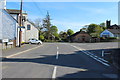
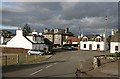
2
Borgue Village
Borgue Village, B727 road junction.
Image: © Chris McAuley
Taken: 6 Aug 2012
0.02 miles
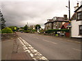
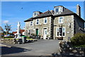
4
The village of Borgue
This small village lies 5 miles southwest of Kirkcudbright in Dumfries and Galloway. The Borgue Hotel is in the central background in this view towards Main Street.
Image: © Walter Baxter
Taken: 30 Aug 2011
0.02 miles
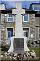
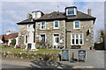
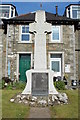
7
Borgue Hotel
On the left is the war memorial.
Image: © Billy McCrorie
Taken: 14 May 2015
0.02 miles
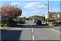
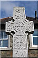
9
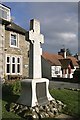
Borgue War Memorial
This granite Celtic cross is in the front garden of the Borgue Hotel.
Image: © Walter Baxter
Taken: 30 Aug 2011
0.02 miles