IMAGES TAKEN NEAR TO
Dundrennan, KIRKCUDBRIGHT, DG6 4QR
Introduction
This page details the photographs taken nearby to DG6 4QR by members of the Geograph project.
The Geograph project started in 2005 with the aim of publishing, organising and preserving representative images for every square kilometre of Great Britain, Ireland and the Isle of Man.

There are currently over 7.5m images from over14,400 individuals and you can help contribute to the project by visiting https://www.geograph.org.uk
Image Map
Images are licensed for reuse under creativecommons.org/licenses/by-sa/2.0
Notes
- Clicking on the map will re-center to the selected point.
- The higher the marker number, the further away the image location is from the centre of the postcode.
Image Listing (16 Images Found)
Images are licensed for reuse under creativecommons.org/licenses/by-sa/2.0
Image
Details
Distance
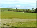
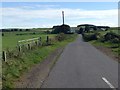
1
Farmland at Stockmoss
Seen from the A711.
Image: © Billy McCrorie
Taken: 23 Sep 2020
0.14 miles
2

Site of old cottage
By the side of the A711 a few yards west of Burnside Bridge, is the site of Burnside, a cottage long since demolished.
Image: © James Bell
Taken: 22 Aug 2010
0.19 miles
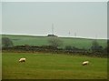
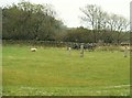
3
Looking across the A711
The view is taken from the gateway into the Wickerman field.
Image: © Ann Cook
Taken: 1 Oct 2011
0.21 miles
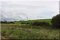
4
Looking towards a mast on Standingstone hill
The field, in the foreground, is the Wickerman field.
Image: © Ann Cook
Taken: 1 Oct 2011
0.21 miles
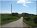
7
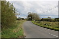
The A711 to Dalbeattie
Near Stockmoss Farm.
Image: © Billy McCrorie
Taken: 23 Sep 2020
0.23 miles
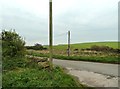
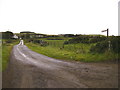
9
Minor road off the A711
Looking down to Stockmoss Smithy.
Image: © David Purchase
Taken: 30 Apr 2018
0.23 miles