IMAGES TAKEN NEAR TO
Abbey Park, KIRKCUDBRIGHT, DG6 4QQ
Introduction
This page details the photographs taken nearby to Abbey Park, DG6 4QQ by members of the Geograph project.
The Geograph project started in 2005 with the aim of publishing, organising and preserving representative images for every square kilometre of Great Britain, Ireland and the Isle of Man.

There are currently over 7.5m images from over14,400 individuals and you can help contribute to the project by visiting https://www.geograph.org.uk
Image Map
Images are licensed for reuse under creativecommons.org/licenses/by-sa/2.0
Notes
- Clicking on the map will re-center to the selected point.
- The higher the marker number, the further away the image location is from the centre of the postcode.
Image Listing (269 Images Found)
Images are licensed for reuse under creativecommons.org/licenses/by-sa/2.0
Image
Details
Distance
1
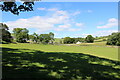
Dundrennan Village
Viewed from the rear of Dundrennan Abbey.
Image: © Billy McCrorie
Taken: 14 Jul 2021
0.01 miles
2

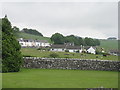
Houses in Dundrennan Village
As seen from the Abbey car park.
Image: © Billy McCrorie
Taken: 23 Sep 2020
0.02 miles
4
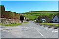
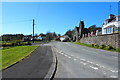
A711, Dundrennan
The eastern side of the village.
Image: © Richard Webb
Taken: 21 Jul 2013
0.05 miles
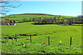
5
Dundrennan village
Looking across from the Abbey.
Image: © M J Richardson
Taken: 20 Jul 2014
0.05 miles
6

Bridgend Bridge, Fagra Road, Dundrennan.
This bridge spans the Abbey Burn near Dundrennan Abbey. It used to be called Bow Bridge.
Image: © James Bell
Taken: 13 Aug 2010
0.05 miles
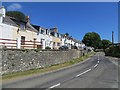
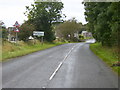
7
The A711 at Dundrennan
The church on the right is now up for sale.
Image: © Billy McCrorie
Taken: 18 Apr 2014
0.05 miles
10
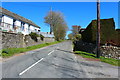
The A711 to Auchencairn leaving Dundrennan
Image: © Billy McCrorie
Taken: 18 Apr 2014
0.06 miles