IMAGES TAKEN NEAR TO
Dundrennan, KIRKCUDBRIGHT, DG6 4QP
Introduction
This page details the photographs taken nearby to DG6 4QP by members of the Geograph project.
The Geograph project started in 2005 with the aim of publishing, organising and preserving representative images for every square kilometre of Great Britain, Ireland and the Isle of Man.

There are currently over 7.5m images from over14,400 individuals and you can help contribute to the project by visiting https://www.geograph.org.uk
Image Map
Images are licensed for reuse under creativecommons.org/licenses/by-sa/2.0
Notes
- Clicking on the map will re-center to the selected point.
- The higher the marker number, the further away the image location is from the centre of the postcode.
Image Listing (5 Images Found)
Images are licensed for reuse under creativecommons.org/licenses/by-sa/2.0
Image
Details
Distance
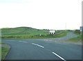
3
A 711 road junction
Road signs at the end of the Whinnieligate road, including a small one directing to Dundrennan Abbey. Looking towards Barend Hill.
Image: © Helen Bowick
Taken: 20 Oct 2010
0.19 miles
4
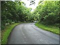
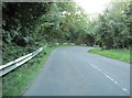
Treelined Roadway (A711) down Balmangan Glen.
Image: © James Bell
Taken: 22 Aug 2010
0.19 miles
5
A711 twists down through the Balmangan Glen
Image: © Ann Cook
Taken: 18 Sep 2010
0.22 miles