IMAGES TAKEN NEAR TO
Dundrennan, KIRKCUDBRIGHT, DG6 4QN
Introduction
This page details the photographs taken nearby to DG6 4QN by members of the Geograph project.
The Geograph project started in 2005 with the aim of publishing, organising and preserving representative images for every square kilometre of Great Britain, Ireland and the Isle of Man.

There are currently over 7.5m images from over14,400 individuals and you can help contribute to the project by visiting https://www.geograph.org.uk
Image Map
Images are licensed for reuse under creativecommons.org/licenses/by-sa/2.0
Notes
- Clicking on the map will re-center to the selected point.
- The higher the marker number, the further away the image location is from the centre of the postcode.
Image Listing (10 Images Found)
Images are licensed for reuse under creativecommons.org/licenses/by-sa/2.0
Image
Details
Distance

2
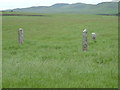
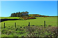
3 Standing Stones
3 stones in a farmer's field near Dundrennan. I suspect they aren't authentic.
Image: © Alison Stamp
Taken: 18 Jun 2005
0.15 miles
3

Abbey Burn, Dundrennan.
Looking north from Barend Bridge on the A711 near Dundrennan
Image: © James Bell
Taken: 13 Aug 2010
0.15 miles
4

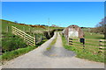
Old Shed at Barend Farm entrance
Near Dundrennan, Parish of Rerrick.
Image: © James Bell
Taken: 13 Aug 2010
0.15 miles
5
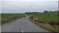
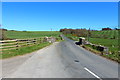
Barend Bridge
The A711 heading towards Auchencairn and Dalbeattie crosses the Barend Bridge.
Image: © Peter Mackenzie
Taken: 11 Apr 2018
0.16 miles
6
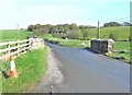
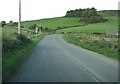
Bridge over the Abbey Burn
This road is the A711 and, after crossing the bridge, it climbs up and through Balmangan Glen.
Image: © Ann Cook
Taken: 3 Oct 2009
0.16 miles
10
Warnings of a narrow bridge and a sharp bend on the A711
The bridge is over the Abbey Burn.
Image: © Ann Cook
Taken: 18 Sep 2010
0.18 miles