IMAGES TAKEN NEAR TO
Dundrennan, KIRKCUDBRIGHT, DG6 4QF
Introduction
This page details the photographs taken nearby to DG6 4QF by members of the Geograph project.
The Geograph project started in 2005 with the aim of publishing, organising and preserving representative images for every square kilometre of Great Britain, Ireland and the Isle of Man.

There are currently over 7.5m images from over14,400 individuals and you can help contribute to the project by visiting https://www.geograph.org.uk
Image Map
Images are licensed for reuse under creativecommons.org/licenses/by-sa/2.0
Notes
- Clicking on the map will re-center to the selected point.
- The higher the marker number, the further away the image location is from the centre of the postcode.
Image Listing (10 Images Found)
Images are licensed for reuse under creativecommons.org/licenses/by-sa/2.0
Image
Details
Distance

2
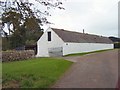
The Thorn
Farm buildings at the Thorn Farm, near Dundrennan
Image: © Helen Bowick
Taken: 21 Sep 2010
0.02 miles
3

Burnside, Rerrick
House looks unlived-in but sound.
Image: © James Bell
Taken: 13 Aug 2010
0.05 miles
4
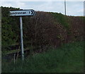
Road sign - Dundrennan 1 mile
The hedge will need cutting back when this year's spring growth starts as part of the place name is missing already. What will it say soon?
Image: © Ann Cook
Taken: 2 May 2009
0.07 miles
5
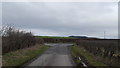
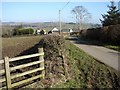
Near to Penbridge Cottage
A minor road junction at this isolated location.
Image: © Peter Mackenzie
Taken: 11 Apr 2018
0.08 miles

8
Auchnabony Farm
View from the side of the Dundrennan-Penbridge lane of Auchnabony Farm and Craigmullen (to left of farm).
Image: © Chris Newman
Taken: 18 Feb 2008
0.23 miles
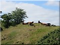
9
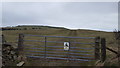
Beware of the bull
Grazing on Bar Hill.
Image: © Peter Mackenzie
Taken: 11 Apr 2018
0.23 miles
10
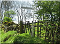
Signpost to Craigmullen farm
This signpost marks the entrance, on the opposite side of the lane, to Craigmullen Farm.
Image: © Ann Cook
Taken: 2 May 2009
0.24 miles