IMAGES TAKEN NEAR TO
KIRKCUDBRIGHT, DG6 4QD
Introduction
This page details the photographs taken nearby to DG6 4QD by members of the Geograph project.
The Geograph project started in 2005 with the aim of publishing, organising and preserving representative images for every square kilometre of Great Britain, Ireland and the Isle of Man.

There are currently over 7.5m images from over14,400 individuals and you can help contribute to the project by visiting https://www.geograph.org.uk
Image Map
Images are licensed for reuse under creativecommons.org/licenses/by-sa/2.0
Notes
- Clicking on the map will re-center to the selected point.
- The higher the marker number, the further away the image location is from the centre of the postcode.
Image Listing (7 Images Found)
Images are licensed for reuse under creativecommons.org/licenses/by-sa/2.0
Image
Details
Distance
1
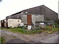
Tongue of Bombie
Former indoor riding arena
Image: © Helen Bowick
Taken: 21 Sep 2010
0.03 miles
2
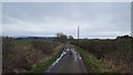
Gribdae Lane
This minor road serves Gribdae Farm.
Image: © Peter Mackenzie
Taken: 11 Apr 2018
0.09 miles
3
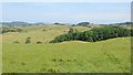
Grassland, Bombie
Complex contouring, typical of Galloway.
Image: © Richard Webb
Taken: 21 Jul 2013
0.17 miles
4
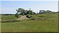
Road and fields, Bombie
Grassland, somewhat parched at the end of a long dry spell.
Image: © Richard Webb
Taken: 21 Jul 2013
0.20 miles
5
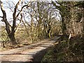
Gribdae Lane
February view eastward along the Tongue of Bombie-Gribdae lane.
Image: © Chris Newman
Taken: 18 Feb 2008
0.21 miles
6
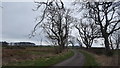
Near Bombie Hill
The minor road near to Bombie Hill.
Image: © Peter Mackenzie
Taken: 11 Apr 2018
0.21 miles
7
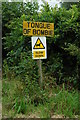
Sign for the delightfully named tongue of Bombie
Image: © Andrya Prescott
Taken: 21 Jul 2006
0.23 miles