IMAGES TAKEN NEAR TO
Twynholm, KIRKCUDBRIGHT, DG6 4PN
Introduction
This page details the photographs taken nearby to DG6 4PN by members of the Geograph project.
The Geograph project started in 2005 with the aim of publishing, organising and preserving representative images for every square kilometre of Great Britain, Ireland and the Isle of Man.

There are currently over 7.5m images from over14,400 individuals and you can help contribute to the project by visiting https://www.geograph.org.uk
Image Map
Images are licensed for reuse under creativecommons.org/licenses/by-sa/2.0
Notes
- Clicking on the map will re-center to the selected point.
- The higher the marker number, the further away the image location is from the centre of the postcode.
Image Listing (9 Images Found)
Images are licensed for reuse under creativecommons.org/licenses/by-sa/2.0
Image
Details
Distance
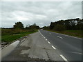
1
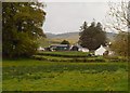
Barbey
View across the A75 towards Barbey Farm.
Image: © Andy Farrington
Taken: 4 Oct 2011
0.05 miles
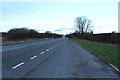
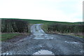
2

Farm road leading to Barbey Farm, Twynholm.
Image: © James Bell
Taken: 19 Aug 2010
0.11 miles
3
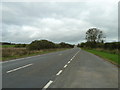
Barbey
View along the A75 towards Dumfries.
Image: © Andy Farrington
Taken: 4 Oct 2011
0.17 miles
6
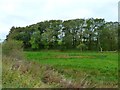
Barbey Wood
View over the A75 to this wood next to Barbey Farm.
Image: © Andy Farrington
Taken: 4 Oct 2011
0.19 miles

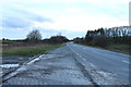
9
Barbey
View along the A75 in the direction of Stranraer
Image: © Andy Farrington
Taken: 4 Oct 2011
0.23 miles