IMAGES TAKEN NEAR TO
DG6 4LN
Introduction
This page details the photographs taken nearby to DG6 4LN by members of the Geograph project.
The Geograph project started in 2005 with the aim of publishing, organising and preserving representative images for every square kilometre of Great Britain, Ireland and the Isle of Man.

There are currently over 7.5m images from over14,400 individuals and you can help contribute to the project by visiting https://www.geograph.org.uk
Image Map
Images are licensed for reuse under creativecommons.org/licenses/by-sa/2.0
Notes
- Clicking on the map will re-center to the selected point.
- The higher the marker number, the further away the image location is from the centre of the postcode.
Image Listing (1168 Images Found)
Images are licensed for reuse under creativecommons.org/licenses/by-sa/2.0
Image
Details
Distance
1
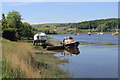
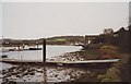
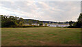
By Castledykes
Boats lying by Castledykes Point.
Image: © Andrew Wood
Taken: 26 May 2017
0.01 miles
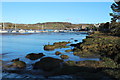
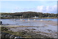
3
Gartshore Park, Kirkcudbright
The River Dee is in the background.
Image: © habiloid
Taken: 26 Jul 2021
0.02 miles
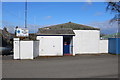
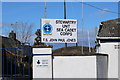
4
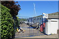
Sea Cadet Station
Being in Kirkcudbright the name of John Paul Jones is not far away as on this Sea Cadet Unit.
Image: © Andrew Wood
Taken: 26 May 2017
0.02 miles