IMAGES TAKEN NEAR TO
Maxwell Wynd, KIRKCUDBRIGHT, DG6 4HJ
Introduction
This page details the photographs taken nearby to Maxwell Wynd, DG6 4HJ by members of the Geograph project.
The Geograph project started in 2005 with the aim of publishing, organising and preserving representative images for every square kilometre of Great Britain, Ireland and the Isle of Man.

There are currently over 7.5m images from over14,400 individuals and you can help contribute to the project by visiting https://www.geograph.org.uk
Image Map
Images are licensed for reuse under creativecommons.org/licenses/by-sa/2.0
Notes
- Clicking on the map will re-center to the selected point.
- The higher the marker number, the further away the image location is from the centre of the postcode.
Image Listing (1458 Images Found)
Images are licensed for reuse under creativecommons.org/licenses/by-sa/2.0
Image
Details
Distance
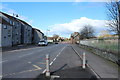
3
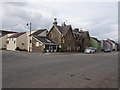
Junction Atkinson Place and St Mary Street
Image: © Billy McCrorie
Taken: 3 Mar 2014
0.04 miles
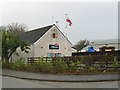
6
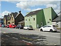
Contrasting building styles, Kirkcudbright
The building on the left is what remains of Kirkcudbright Railway Station, built for the Kirkcudbright Railway (a branch line from Castle Douglas to Kirkcudbright) which opened in 1864 and closed in 1965. The station building now houses the Station House Cafe and Cookery School. I have no information on the green building.
Image: © Richard Sutcliffe
Taken: 16 May 2018
0.04 miles
7
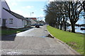
Path to Tongland Old Bridge at Kirkcudbright
Image: © Billy McCrorie
Taken: 3 Mar 2014
0.04 miles
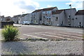
8
Kirkcudbright railway station (site), Dumfries & Galloway
Opened in 1864 by the Kirkcudbright Railway, soon to become part of the Glasgow & South Western Railway, as the terminus on the line from Castle Douglas, this station closed in 1965.
View north from the road at the old station building. Behind the building, the railway terminated at buffers under a large trainshed, where the lighter coloured houses now are.
Image: © Nigel Thompson
Taken: 7 May 2019
0.04 miles
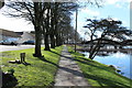
10
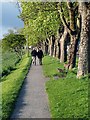
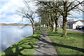
The Dee Walk at Kirkcudbright
This riverside path in the town centre is on the southeast side of the River Dee.
Image: © Walter Baxter
Taken: 22 May 2013
0.05 miles