IMAGES TAKEN NEAR TO
Atkinson Place, KIRKCUDBRIGHT, DG6 4EH
Introduction
This page details the photographs taken nearby to Atkinson Place, DG6 4EH by members of the Geograph project.
The Geograph project started in 2005 with the aim of publishing, organising and preserving representative images for every square kilometre of Great Britain, Ireland and the Isle of Man.

There are currently over 7.5m images from over14,400 individuals and you can help contribute to the project by visiting https://www.geograph.org.uk
Image Map
Images are licensed for reuse under creativecommons.org/licenses/by-sa/2.0
Notes
- Clicking on the map will re-center to the selected point.
- The higher the marker number, the further away the image location is from the centre of the postcode.
Image Listing (798 Images Found)
Images are licensed for reuse under creativecommons.org/licenses/by-sa/2.0
Image
Details
Distance
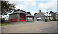
1
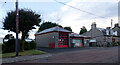
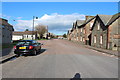
Fire Station, St. Mary Street (A711), Kirkcudbright
Image: © habiloid
Taken: 28 Jul 2021
0.02 miles
2
Atkinson Place, St. Mary Street, Kirkcudbright
Image: © habiloid
Taken: 28 Jul 2021
0.03 miles
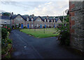
3
Atkinson Place, St. Mary Street, Kirkcudbright
Image: © habiloid
Taken: 28 Jul 2021
0.03 miles
4
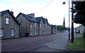
Atkinson Place, St. Mary Street, Kirkcudbright
Image: © habiloid
Taken: 28 Jul 2021
0.03 miles
5
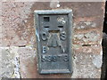
Ordnance Survey Flush Bracket S9978
This can be found on the wall of a house at Atkinson Place.
For more detail see : http://www.bench-marks.org.uk/bm11433
Image: © Peter Wood
Taken: 26 Sep 2013
0.03 miles
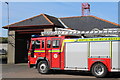
7
Fire Station, Kirkcudbright
On the A711, St Mary Street.
Image: © Richard Sutcliffe
Taken: 16 May 2018
0.03 miles
8
Junction of St. Mary Street (A711) and Dee Road, Kirkcudbright
Image: © habiloid
Taken: 28 Jul 2021
0.03 miles
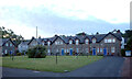
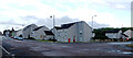
10
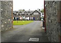
Atkinson's Place, St Mary Street
Late 19th century alms houses, built using funds given by Edward Atkinson to the Kirk session of St Cuthbert's. Category C-listed [http://portal.historicenvironment.scot/designation/LB36618].
Image: © Richard Sutcliffe
Taken: 16 May 2018
0.03 miles