IMAGES TAKEN NEAR TO
School Close, KIRKCUDBRIGHT, DG6 4DD
Introduction
This page details the photographs taken nearby to School Close, DG6 4DD by members of the Geograph project.
The Geograph project started in 2005 with the aim of publishing, organising and preserving representative images for every square kilometre of Great Britain, Ireland and the Isle of Man.

There are currently over 7.5m images from over14,400 individuals and you can help contribute to the project by visiting https://www.geograph.org.uk
Image Map
Images are licensed for reuse under creativecommons.org/licenses/by-sa/2.0
Notes
- Clicking on the map will re-center to the selected point.
- The higher the marker number, the further away the image location is from the centre of the postcode.
Image Listing (156 Images Found)
Images are licensed for reuse under creativecommons.org/licenses/by-sa/2.0
Image
Details
Distance
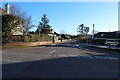
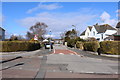
1
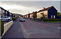
Castledykes Road
In the southern suburbs of Kirkcudbright.
Image: © Oliver Dixon
Taken: 20 Sep 2020
0.02 miles
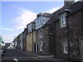
2
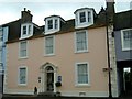
Baytree House B&B High Street Kirkcudbright
Beautiful Georgian property which is a 4*B&B with gorgeous ensuite letting rooms and a self-catering studio apartment through the pend to the rear of the property.
Image: © Gerry
Taken: 29 Mar 2009
0.03 miles
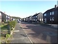
5
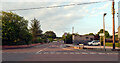
Longacres Road seen from Castledykes Road, Kirkcudbright
Image: © habiloid
Taken: 26 Jul 2021
0.04 miles
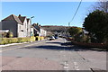
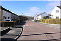
9
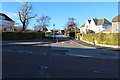
St Mary's Wynd, Kirkcudbright
The road to the primary school and academy.
Image: © Billy McCrorie
Taken: 3 Mar 2014
0.06 miles