IMAGES TAKEN NEAR TO
Barrhill Terrace, KIRKCUDBRIGHT, DG6 4BU
Introduction
This page details the photographs taken nearby to Barrhill Terrace, DG6 4BU by members of the Geograph project.
The Geograph project started in 2005 with the aim of publishing, organising and preserving representative images for every square kilometre of Great Britain, Ireland and the Isle of Man.

There are currently over 7.5m images from over14,400 individuals and you can help contribute to the project by visiting https://www.geograph.org.uk
Image Map
Images are licensed for reuse under creativecommons.org/licenses/by-sa/2.0
Notes
- Clicking on the map will re-center to the selected point.
- The higher the marker number, the further away the image location is from the centre of the postcode.
Image Listing (1363 Images Found)
Images are licensed for reuse under creativecommons.org/licenses/by-sa/2.0
Image
Details
Distance
5
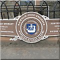
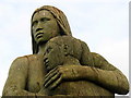
Bridge plaque, The Stewartry Museum
One of a pair outside the museum.
Image: © Richard Webb
Taken: 21 Jul 2013
0.06 miles
8
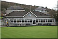
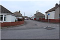
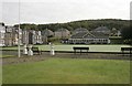
Kirkcudbright Bowling Clubhouse
Viewed from Church Place.
Image: © Billy McCrorie
Taken: 27 Feb 2023
0.06 miles
10
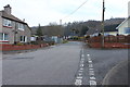
Kirkcudbright Bowling Club
Viewed from St Mary Street. The houses on the left are on Church Place.
Image: © Richard Sutcliffe
Taken: 22 Oct 2016
0.06 miles