IMAGES TAKEN NEAR TO
St. Mary Street, KIRKCUDBRIGHT, DG6 4AQ
Introduction
This page details the photographs taken nearby to St. Mary Street, DG6 4AQ by members of the Geograph project.
The Geograph project started in 2005 with the aim of publishing, organising and preserving representative images for every square kilometre of Great Britain, Ireland and the Isle of Man.

There are currently over 7.5m images from over14,400 individuals and you can help contribute to the project by visiting https://www.geograph.org.uk
Image Map
Images are licensed for reuse under creativecommons.org/licenses/by-sa/2.0
Notes
- Clicking on the map will re-center to the selected point.
- The higher the marker number, the further away the image location is from the centre of the postcode.
Image Listing (1744 Images Found)
Images are licensed for reuse under creativecommons.org/licenses/by-sa/2.0
Image
Details
Distance
1
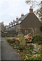
Garden on Church Row, Kirkcudbright
Facing Church Row.
Image: © Billy McCrorie
Taken: 27 Feb 2023
0.01 miles
2
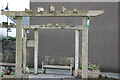
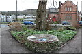
Pergola, Kirkcudbright
In the Garden at Church Row.
Image: © Billy McCrorie
Taken: 27 Feb 2023
0.01 miles
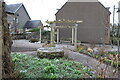
4
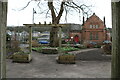
Garden on Church Row, Kirkcudbright
Looking out across St. Mary Street with the Bowling Green on the left.
Image: © Billy McCrorie
Taken: 27 Feb 2023
0.01 miles
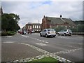
5
Garden on Church Row, Kirkcudbright
Looking onto St. Mary Street.
Image: © Billy McCrorie
Taken: 27 Feb 2023
0.01 miles
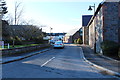
7
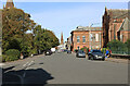
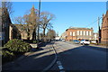
St. Mary Street, Kirkcudbright
Also the A711.
Image: © Billy McCrorie
Taken: 27 Sep 2020
0.02 miles