IMAGES TAKEN NEAR TO
DALBEATTIE, DG5 4PH
Introduction
This page details the photographs taken nearby to DG5 4PH by members of the Geograph project.
The Geograph project started in 2005 with the aim of publishing, organising and preserving representative images for every square kilometre of Great Britain, Ireland and the Isle of Man.

There are currently over 7.5m images from over14,400 individuals and you can help contribute to the project by visiting https://www.geograph.org.uk
Image Map
Images are licensed for reuse under creativecommons.org/licenses/by-sa/2.0
Notes
- Clicking on the map will re-center to the selected point.
- The higher the marker number, the further away the image location is from the centre of the postcode.
Image Listing (9 Images Found)
Images are licensed for reuse under creativecommons.org/licenses/by-sa/2.0
Image
Details
Distance
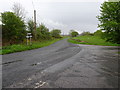
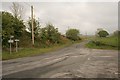
2
Approaching the turning to Dalbeattie
Turn left at this junction for Dalbeattie.
Image: © Ann Cook
Taken: 4 Oct 2012
0.13 miles
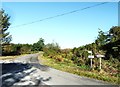
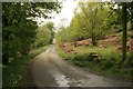
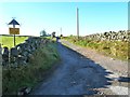
7
No through road
This track leads to Drumfada.
Image: © Ann Cook
Taken: 4 Oct 2012
0.20 miles
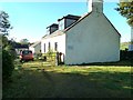
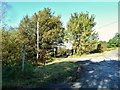
8
The road to the Isles
This track leads to Isles bungalow and Isles farm.
Image: © Ann Cook
Taken: 4 Oct 2012
0.23 miles