IMAGES TAKEN NEAR TO
DALBEATTIE, DG5 4EQ
Introduction
This page details the photographs taken nearby to DG5 4EQ by members of the Geograph project.
The Geograph project started in 2005 with the aim of publishing, organising and preserving representative images for every square kilometre of Great Britain, Ireland and the Isle of Man.

There are currently over 7.5m images from over14,400 individuals and you can help contribute to the project by visiting https://www.geograph.org.uk
Image Map
Images are licensed for reuse under creativecommons.org/licenses/by-sa/2.0
Notes
- Clicking on the map will re-center to the selected point.
- The higher the marker number, the further away the image location is from the centre of the postcode.
Image Listing (12 Images Found)
Images are licensed for reuse under creativecommons.org/licenses/by-sa/2.0
Image
Details
Distance
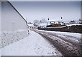
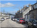
2
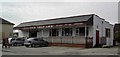
Millo Place garage on Dalbeattie High Street
Image: © Hugh Close
Taken: 19 Dec 2010
0.19 miles
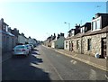
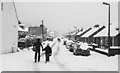
3
Houses, High Street, Dalbeattie
The postbox is number DG5 51D [http://www.geograph.org.uk/photo/5581796].
Image: © Richard Sutcliffe
Taken: 27 Oct 2017
0.20 miles
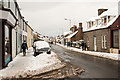
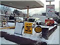
4
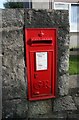
Postbox, High Street, Dalbeattie
Postbox number DG5 51D.
Image: © Richard Sutcliffe
Taken: 27 Oct 2017
0.20 miles
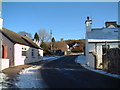
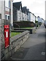
5
The Ship Inn.
A popular watering hole in Dalbeattie.
Image: © Colin Kinnear
Taken: 3 May 2008
0.23 miles