IMAGES TAKEN NEAR TO
High Street, DALBEATTIE, DG5 4AD
Introduction
This page details the photographs taken nearby to High Street, DG5 4AD by members of the Geograph project.
The Geograph project started in 2005 with the aim of publishing, organising and preserving representative images for every square kilometre of Great Britain, Ireland and the Isle of Man.

There are currently over 7.5m images from over14,400 individuals and you can help contribute to the project by visiting https://www.geograph.org.uk
Image Map
Images are licensed for reuse under creativecommons.org/licenses/by-sa/2.0
Notes
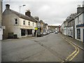
- Clicking on the map will re-center to the selected point.
- The higher the marker number, the further away the image location is from the centre of the postcode.
Image Listing (310 Images Found)
Images are licensed for reuse under creativecommons.org/licenses/by-sa/2.0
Image
Details
Distance
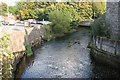
1
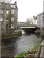
Kirkgunzeon Burn
River flowing through Dalbeattie. Home to dippers.
Image: © Richard Webb
Taken: 25 Apr 2010
0.01 miles
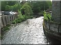
5
Dalbeattie Burn
Flowing past one of Dalbeattie's car parks. Photographed from the High Street bridge.
Image: © Richard Sutcliffe
Taken: 14 Oct 2016
0.02 miles
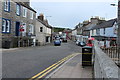
6
Kirkgunzeon Lane looking east
This view is taken from the High Street bridge.
Image: © Ann Cook
Taken: 27 May 2011
0.02 miles
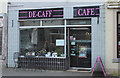
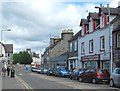
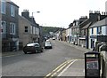
9
High Street, Dalbeattie
The shop premises on the left (previously Idlehour Gifts) are empty and are to let at present.
Image: © Richard Sutcliffe
Taken: 25 Oct 2017
0.02 miles
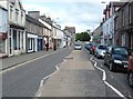
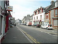
10
High Street, Dalbeattie
This view is taken from the bridge over Kirkgunzeon Lane.
Image: © Ann Cook
Taken: 27 May 2011
0.02 miles