IMAGES TAKEN NEAR TO
Kirkconnel, SANQUHAR, DG4 6NN
Introduction
This page details the photographs taken nearby to DG4 6NN by members of the Geograph project.
The Geograph project started in 2005 with the aim of publishing, organising and preserving representative images for every square kilometre of Great Britain, Ireland and the Isle of Man.

There are currently over 7.5m images from over14,400 individuals and you can help contribute to the project by visiting https://www.geograph.org.uk
Image Map
Images are licensed for reuse under creativecommons.org/licenses/by-sa/2.0
Notes
- Clicking on the map will re-center to the selected point.
- The higher the marker number, the further away the image location is from the centre of the postcode.
Image Listing (17 Images Found)
Images are licensed for reuse under creativecommons.org/licenses/by-sa/2.0
Image
Details
Distance
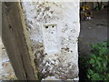
1
Ordnance Survey Cut Mark
This can be found on the wall of the farmhouse at The Knowe.
For more detail : http://www.bench-marks.org.uk/bm62672
Image: © Peter Wood
Taken: 26 Sep 2014
0.11 miles
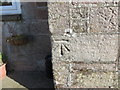
2
Ordnance Survey Flush Bracket G4494
This can be found on the wall of a building at The Knowe.
For more detail see : http://www.bench-marks.org.uk/bm17343
Image: © Peter Wood
Taken: 26 Sep 2014
0.11 miles
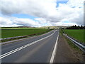
3

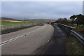
Road and Barn at The Knowe
Looking north-westward.
Image: © Peter Wood
Taken: 26 Sep 2014
0.11 miles
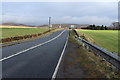
4
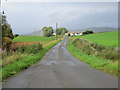
Road heading towards The Knowe
Looking north-westward.
Image: © Peter Wood
Taken: 10 Sep 2017
0.14 miles