IMAGES TAKEN NEAR TO
SANQUHAR, DG4 6JZ
Introduction
This page details the photographs taken nearby to DG4 6JZ by members of the Geograph project.
The Geograph project started in 2005 with the aim of publishing, organising and preserving representative images for every square kilometre of Great Britain, Ireland and the Isle of Man.

There are currently over 7.5m images from over14,400 individuals and you can help contribute to the project by visiting https://www.geograph.org.uk
Image Map
Images are licensed for reuse under creativecommons.org/licenses/by-sa/2.0
Notes
- Clicking on the map will re-center to the selected point.
- The higher the marker number, the further away the image location is from the centre of the postcode.
Image Listing (24 Images Found)
Images are licensed for reuse under creativecommons.org/licenses/by-sa/2.0
Image
Details
Distance
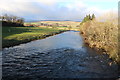
2
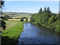
River Nith
View upstream from Blackaddie Bridge
Image: © Richard Webb
Taken: 8 Aug 2012
0.07 miles
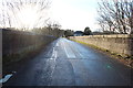
4
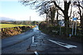
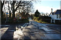
Southern Upland Way near Sanquhar
Which turns right just over the bridge.
Image: © Billy McCrorie
Taken: 9 Jan 2014
0.08 miles
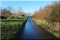
5
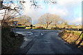
Southern Upland Way near Sanquhar
Waymarker post is next to the give way sign you turn right.
Image: © Billy McCrorie
Taken: 9 Jan 2014
0.08 miles
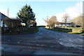
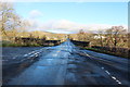
6
Southern Upland Way, Sanquhar
Crossing Blackaddie bridge.
Image: © Billy McCrorie
Taken: 9 Jan 2014
0.08 miles
8
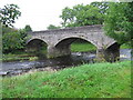
Blackaddie Bridge over the River Nith at Sanquhar
Image: © Chris Wimbush
Taken: 2 Sep 2006
0.09 miles