IMAGES TAKEN NEAR TO
The Yard, SANQUHAR, DG4 6BJ
Introduction
This page details the photographs taken nearby to The Yard, DG4 6BJ by members of the Geograph project.
The Geograph project started in 2005 with the aim of publishing, organising and preserving representative images for every square kilometre of Great Britain, Ireland and the Isle of Man.

There are currently over 7.5m images from over14,400 individuals and you can help contribute to the project by visiting https://www.geograph.org.uk
Image Map
Images are licensed for reuse under creativecommons.org/licenses/by-sa/2.0
Notes
- Clicking on the map will re-center to the selected point.
- The higher the marker number, the further away the image location is from the centre of the postcode.
Image Listing (335 Images Found)
Images are licensed for reuse under creativecommons.org/licenses/by-sa/2.0
Image
Details
Distance
2
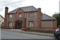
Former Drill Hall - Station Road
Now a community centre. Corner chimney detail similar to Dalbeattie Drill Hall.
Image: © John M
Taken: 22 Jul 2015
0.03 miles
3
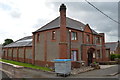
Former Drill Hall - Station Road
Now a community centre.
Image: © John M
Taken: 22 Jul 2015
0.03 miles
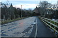
7
Red sandstone houses on Buccleuch Road, Sanquhar
Image: © JThomas
Taken: 22 May 2021
0.04 miles